|

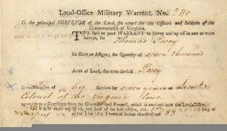
Thomas Posey
Military Warrant 240 Seven Thousand Acres for 7 years service
as a Lieutenant Colonel of the Virginia Line
dated 1 April 1783
Click on image to enlarge

Zephaniah Posey
Military Warrant 2962 One Hundred Acres for 3 years service
as a soldier in the Virginia
Continental Line
dated 19 April 1784
Click on image to enlarge
HISTORICAL MILITARY LINE NOTE
Several titles adjacent to this property and as back reference to this
property refer to The "MILITARY LINE". One adjacent title refers to the
"POSEY MILITARY LINE". This line is a portion of the eastern boundary of
this tract and continues southward from this tract.
There were two Revolutionary War Land Grants to Posey’s. The first being 7000
acres to, Lieutenant Colonel of the Virginia State Line Unit, by
warrant number 240 dated April 1, 1783. The second being 100 acres to Zephaniah
Posey, soldier of the Virginia Continental Line Unit, by warrant number 2962 dated
April 19, 1784.
Based on the date of these warrants the grant would have been in Lincoln County,
which was formed in 1780. Logan County was formed from Lincoln County in 1792.
Christian County was formed from Logan County in 1792, and Livingston County was
formed from Christian County in 1798.
Presumably this line would be a portion of the Thomas Posey Warrant due to the
physical length of the line vs. the 7000 acre grant.
This information has not been verified, however, this line location is suspect
through the title research for this survey.
Note:
A military line is the legal reference used by attorneys and surveyors, all
past, not present, to describe the exterior line of a piece of land that was
acquired through a military grant. These lines were surveyed by a small
group of District Surveyors. Attached is a brief history of these surveyors
that worked within the limits of Kentucky.
All of the above information was submitted by:
Gerald M. Kight, EI, PLS
Vice President
Florence & Hutcheson, Inc.
2550 Irvin Cobb Drive
Paducah, KY 42003
|