Rawlings
and Emmons
Pioneer
Land in Fleming County Kentucky
1800
- 1815
Author: Stu Rawlings, August 2010
Reference:
Stephanie Johnson Denton, Mike Rawlings
Contents
Locating
the Mosby 30,000 Acres
Dividing
the Mosby 30,000 Acres
Edward
Warren 1800 - 120 acres - Dbk C pg 26-27
William
Rawlings Sr 1800 - 75 acres - Dbk A1 pg 195-196
Jacob
Worthington 1800 - 50 acres - Dbk A1 pg 194
James
Saunders 1800 - 137 acres - Dbk A2 pg 100,
Philip
Weaver 1801 - 134 acres - Dbk B2 pg 225-226
Thomas
Rawlings 1804 - 53 acres - Dbk B pg 341-343
Thomas
Rawlings 1805 - 134 acres - Dbk C pg 169
Thomas
Rawlings 1809 - 107 acres - Dbk C pg 470
William
Rawlings Jr 1809 - 8 acres - Dbk D pg 21-22
William
Emmons 1813 - 8 acres - Dbk E pg 434
William
Rawlings Jr 1813 - 4 acres - Dbk e pg 432-433
William
Rawlings Jr 1813 - 21 acres - Dbk E - pg 351-352
Joseph
Emmons 1813 - 364 acres - Dbk E pg 354-356
Charles
Emmons 1813 - 70 acres - Dbk E pg 352-354
William
Emmons 1813 - 99 acres - Dbk E pg 366-368
Appendix
A – Mosby Land Patent Surveys
Appendix
B – Mosby Lott Survey
Within ten years of 1776, the era of
claiming land in the area of Kentucky began in earnest.
Up until Kentucky Statehood in 1792, the
area was considered to be a county of the Commonwealth of Virginia.
It was known as Kentucky County, Virginia.
There were three typical ways to claim a
piece of the Kentucky wilderness:
1.
A promise by the government for land in payment for service in the
military, called a military land warrant. First
military land warrants were for service in the Revolutionary War, and other
military land warrants were issued in later conflicts to include the War of 1812
and the US Civil War.
2.
A promise by the government for land for which a fee was paid into the
general US Treasury, called a non-military land warrant.
3.
An ability to make a claim for unclaimed land where a structure was built
and a crop of corn was planted and nurtured for at least one season.
These were called Certificates of Settlement and Pre-emption warrants.
Finding many references to Rawlings clan
members being in Fleming County
Kentucky during the first half of the 1800’s, we undertook a focus search on
deeds in the county archives.
[Note: courthouse site work courtesy
Stephanie Johnson Denton, Hillsboro, Kentucky.]
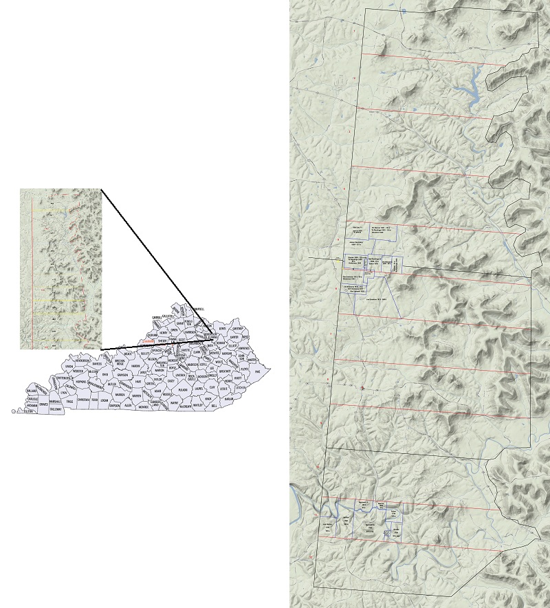
We discovered that the area of Fleming
County where the first Rawlings of Kentucky inhabited was first surveyed for a
series of land patents based on non-military land warrants back in the early
1780’s. The larger collection of
property from which our Rawlings pioneer ancestors purchased their homesteads
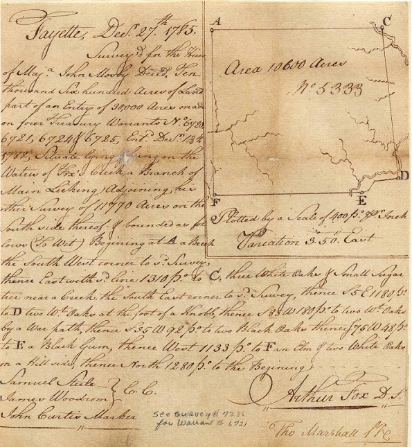
was warranted to Major John Mosby for 30,000 acres. Three original contiguous land patent surveys were found to
cover these 30,000 acres.
The three Mosby land patents were
surveyed out in 1785, based on warrants issued in 1782.
John Mosby’s heir, Littleberry Mosby, exercised the family’s Fleming
County Kentucky land warrants and had them surveyed into the three land patents.
By 1798 these 30,000 acres had been
surveyed, claimed, and legally owned by Littleberry Mosby, but at that time had
not been deeded to private settlers. In
this year 1798 Lewis Craig was contracted by Mosby to create twelve major
divisions (which they called lotts) from the 30,000 acres. Nearly half of the land would go to Craig for his services,
with just over half being retained by Mosby.
Mosby later contracted Craig and others to actually deed the Mosby part
of the land to pioneer land purchasers.
We found the original land patent surveys of the 30,000 acres, and the subsequent legal deed description of the surveyed twelve lots. The foundation steps are to locate and plot these major land definition points.
A search through the Kentucky Secretary
of State web site for historical artifacts produced a listing of all
non-military land warrants issued for Kentucky.
Within this list are many Mosby claims, including John, Littleberry, and
other Mosbys. Though some land was
up on the Ohio River, there were three patents surveyed out and claimed from the
Locust and Fox creek areas of Fleming County.
These three surveys are included here as
Appendix A.
The steps to locate these 30,000 acres
were:
· Confirm likely area of Fleming County where the 30,000 acres would exist based on descriptions in the land patents:
o Patent # 7236 was placed as “......11770 acres...about a N.E. course from the upper Blue Lick on Fox's Creek a branch of the main Licking, Flemming fork......” and then goes on to describe specific landmarks as starting points. Their use of ‘Blue Lick’ was for the Blue Run area east of modern day Flemingsburg.
o Patent # 7229 was placed as “...10600 acres...adjoining his other survey of 11770 acres on the south side thereof...”.
o
Patent # 7258 was placed as “...adjoining his
other survey of 10600 acres on the south side...”.
·
Obtain a current topographic map of the area
between Hillsboro and Flemingsburg, Kentucky.
This was obtained from Google Maps.
·
Convert Poles and Links to feet and inches for
convenience.
·
Using the scale of the topo map, create a 2-D
paper model of the primary patent # 7236.
·
Look to see if there’s a visual fit of the
model to apparent land features. Fortunately,
the three patents of Mosby contained some irregular borders that could be
matched to land features.
Once the first patent survey was placed,
the second and third surveys followed. Their
descriptions place them as laying contiguously, so the next step would be to
examine for same-length borders across two patents.
A common length border was discovered
between south border of top patent (# 7236) and the north border of the middle
patent (# 7229). Another common
length border of a different length was discovered between the middle patent and
the bottom patent (# 7258).
For the bottom patent it was apparent
the deed was drawn with a rotation of 90 degrees counter-clockwise.
The patent survey as drawn needs to be rotated 90 degrees clockwise to
fit.
Following the landmark description in
the top patent, and placing of the paper model onto the topo map, a correct
placement was found. After
measuring in each of the next two patent surveys the final measurements were
accurate to a visual ten poles (165 feet) over a length of 4,040 poles (66,660
feet). That produces a statistical
margin of error of .002, or two tenths of one percent.
Pretty good for any day!
Now we look at that original survey, which is about 20 square miles (5
miles by 4 miles) and at the headwaters of the Fox, to match up with the
description. We’re looking at a
major waterway heading SSE from the top of the Fox, and according to the hand
drawn survey in 1785 we are watching for a watershed area with some other water
flowing NW from the NW corner, and W from along the western border.
We will keep in mind they didn’t have GPS or satellite topo maps back
then. So best case, if we can find
a referenced area to match up, it likely wouldn’t match up exactly.
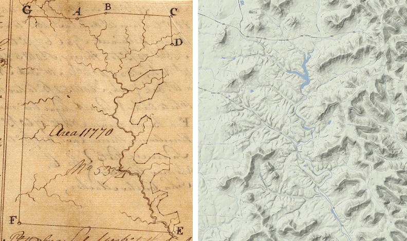
The following location came into view:
The above images are (L) the hand drawn survey from 1785, and (R)
today’s Google topo map.
Looking over the entire region of Fleming Co a better parallel was not
found other than between these two depicted areas. Further confirmation is found when additional surveys are
added to the base map.
Today’s topo map shows a couple of new features, including one or more
dams and small reservoirs where only streams once flowed.
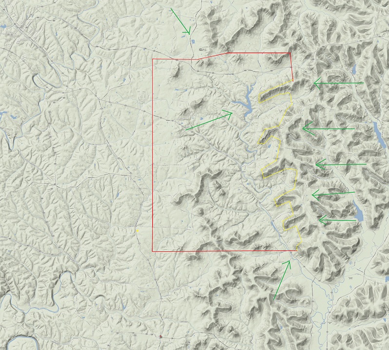
Overlaying the survey onto the topo map gives:
Key points:
·
Point A is one half mile south of small pond: green arrow at top.
·
There are five cutouts on the east border of the survey, matching five
ridges: green arrows on the right.
·
The SE corner point E is just east of Fox Creek.
·
The center top water feature, now a dam and reservoir, matches where the
double-line trace of the upper Fox Creek ends on the survey and remaining creek
beds north and east on the survey become single line traces: green arrow in the
middle.
A yellow star is placed on the map near and outside of the SW corner of
the survey, showing where Crain Cemetery is.
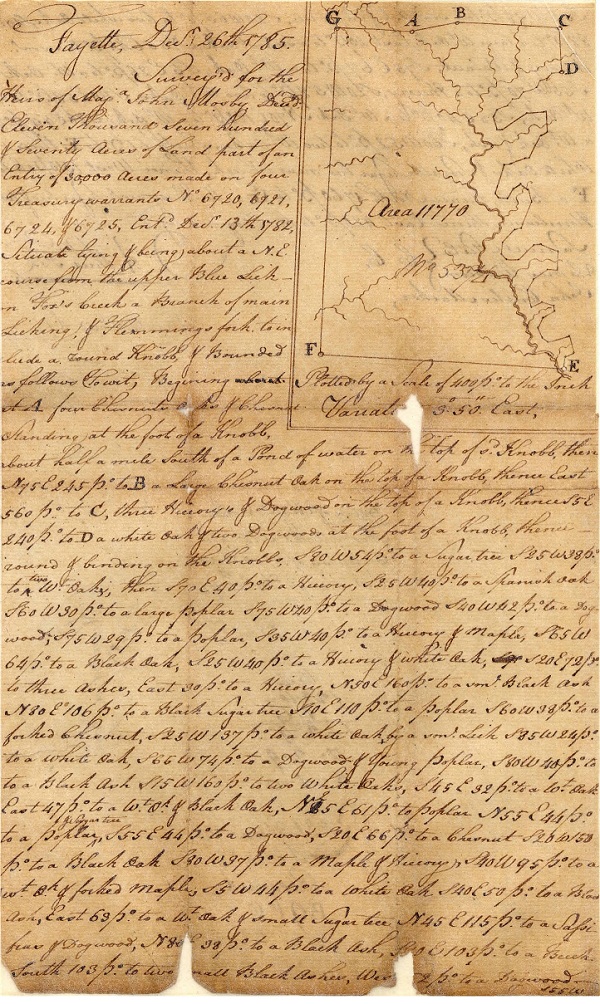
An example using discreet survey steps:
·
Beginning at A four chestnuts
... standing at the foot of a knobb, about half a mile south of a pond of water
on the top of said knobb.
·
Then north 5 degrees (of) east 245 poles to B a large chestnut oak on the top of a knobb.
·
Then east 560 poles to C,
three hickory's and dogwood on the top of a knobb.
·
Thence south 5 degrees (of) east 240 poles to D a white oak and two dogwoods at the foot of a knobb.
·
Thence round and binding on the knobs (ridges), south 80 degrees (of)
west 54 poles to a sugar tree.
·
(Then) south 25 degrees west 38 poles to two white oaks, then...
·
...numerous steps to skirt five unwanted ridges on the eastern survey
border...
·
...to E three white oaks and
small sugar tree near a creek.
·
Thence west 1310 pole to F a
beech.
·
Thence north 1760 poles to G a
mulberry and sugar tree and two hornbeams.
·
Thence east 420 poles to the beginning.
Later
plotting of the intricate eastern border of the top Mosby land patent survey
proved similarly accurate.
The
middle and bottom patent surveys were laid out with similar approach.
They are illustrated in the next section, along with the subsequent
division lines.
Finding
magnetic north on today’s maps compared to those in the 1800 time frame in the
Hillsboro, Kentucky area requires rotating the deed gridlines about 4.2 degrees
clockwise.
This
clockwise shift was applied to the deed descriptions used for this mapping,
which brings the known geographic points of the Mosby NE borders and the Long
Run Branch references correctly in line. The
remainder of the mapping flows from this adjustment.
Several
different lott numbers were observed. The
deeds we were primarily interested in would lie on Lott # 5.
Early
attempts to theorize the boundaries of these Mosby lotts didn’t fully resolve
their placements.
Stephanie
Denton searched for and located the actual early legally recorded deed with
survey activities that created these lotts.
The deed was dated in 1798.
A
sample page from the deed and the entire deed transcript is in Appendix B.
Subsequent
plotting of the lotts as described in the deed yielded the mapping on the right:
[Note:
try viewing with a zoom of 200% for best viewing.]
The
years 1799 through 1813 were the “pioneer settler” years.
During these years Lewis Craig made several forays into the 30,000 acre
area surveying and selling private deeds to individual settlers.
Lots of various sizes were sold, from 5 to over 500 acres depending on
the purchaser.
Craig
spent a large part of 1799 in the area of Lotts 8 through 11.
He did pass by Lott 5 at one point and sold the earliest recorded deed of
that lott to James Saunders. This
was an oddly shaped deed, comprising a single thin line of land along the border
between Lotts 5 & 6 and being 165 feet wide and over 11,000 feet long. No subsequent information has been found to explain this
single purchase in 1799.
In
1800 Craig sold a flurry of deeds on the west side of Lotts 5 and 6.
William Rawlings Sr, b.1735 in Loudoun County VA, was one of four first
settlers on Lott 5, established in the year 1800.
They included Edward Warren, Wm Rawlings Sr, Jacob Worthington, and James
Saunders. In 1813 the Emmons clan
purchased property to fill in Lott 6.
[Stephanie
Johnson Denton is connected to the Emmons clan.]
The
following snippets represent each of these early settler deeds.
Rationale is provided for deriving placement of the deeds where possible
for clarity.
Edward Warren 1800 - 120 acres - Dbk C pg 26-27,
southwest corner of Lott 5.
Mentions neighbor deeds as William Rowlands to the east, James Saunders
to the north, and John Winn to the south. Sold
to Thomas Rawlings in 1809.
“beginning
at a blue ash and white oak thence east one hundred and seventy poles to a
[stake] thence south one hundred nine poles to a [stake] thence west one hundred
and seventy poles to a [stake] thence north one hundred and nine pole to the
beginning, containing one hundred and twenty acres and border to the north by
James Saunders land & on the east by William Rollings land and in the south
by John Winn”
William Rawlings Sr 1800 - 75 acres - Dbk A1 pg
195-196, places
NE corner next to NW corner of Jacob Worthington.
Deed mentions being part of the third subdivision; no other reference to
a subdivision is found in any other deed.
“...beginning at two sugar trees it
being Jacob Worthingtons North West corner running South one hundred &
thirteen poles to a stake, thence West one hundred and two poles to two sugar
trees, thence North one hundred and thirteen poles to a sugar tree and blue ash,
thence East one hundred and two poles to the place of beginning to contain
seventy five acres and to lay within lines of fifth division and third
subdivision of Mosby Thirty Thousand acres...”
Jacob Worthington 1800 - 50 acres - Dbk A1 pg 194,
places south border along the
line between Lotts 5 & 6.
“...bring part of Lott No 5 of Mosby
thirty thousand acres ... and bounded as follows (to wit) beginning at [Samuel]
Powers North East corner thence south on hundred and seventeen poles to a point
in the line between No 5 & No 6 thence along said line east sixty nine poles
to a stake thence north one hundred & seventeen poles thence west sixty nine
poles to the beginning. ...fifty
acres...”
James Saunders 1800 - 137 acres - Dbk A2 pg 100,
places this property at the
SW corner to Will Day’s survey of 68 acres.
No Day deed was located. Possibly
a promised deed that Day backed out of purchasing?
The specific length and notch in the southern border exactly fits the
adjacent border areas of Edward Warren and William Rawlings Sr deeds.
“...one hundred and seventy five
pounds...Craig sold unto said James Saunders all that tract or parcel of land
containing one hundred and thirty seven acres, situate lying and being in the
county of Fleming and on the waters of Locust and bounded as follows (to wit)
Beginning SW corner to Will Day's survey of sixty eight acres being part of
30,000 acres and including Thomas Brown plantation and running south one hundred
nine and a half poles thence east one hundred and seventy poles thence north
nine and half poles then east twenty three poles thence north ten degrees east
one hundred and ten poles thence west forty six poles thence south seven and a
half poles thence west one hundred and sixty four poles to the beginning.”
Philip Weaver 1801 - 134 acres - Dbk B2 pg 225-226,
no identifying land marks.
Sold to Thomas Rawlings in 1805.
“...one certain tract or parcel of
land containing by survey one hundred and thirty four acres and three fourths
and eight poles situated lying and being in the aforesaid county of Flemming on
the waters of Locust Creek being a part of the No 5 one of the lotts of thirty
thousand acres patented in the name of littleberry mosby heir at law to john
mosby decd and bounded as follows (to wit) beginning at a sugar tree and hickory
thence west forty four poles thence north four poles to two white oaks thence
west on hundred and forty eight poles to a blue ash and sugar tree thence north
one hundred and eight and one third poles to an ash and sugar tree thence east
one hundred ninety two and one half poles to two small sugar trees thence south
to the place of beginning.”
Thomas Rawlings 1804 - 53 acres - Dbk B pg 341-343,
purchased from Sam Powell
1800 deed. This is Thomas
Rawlings’s first property, possibly the location of his first house.
“...containing by survey fifty three
acres and three quarters and bounded as follows (to wit) Beginning at Jacob
Witheringtons north east corner a sugar tree and box elder thence along
Witheringtons line south one hundred and seventeen and one third poles to said
witheringtons south east corner a stake and slippery elm in the line between No
5 & No 6 thence along said line east seventy three and one third poles to a
large white oak thence north one hundred and seventeen and one third poles to a
stake thence west seventy three and one third poles to the beginning it being
part of Lot No 5 one of the lots of the thirty thousand acres...”
Thomas Rawlings 1805 - 134 acres - Dbk C pg 169,
purchased from Philip Weaver
1801 deed. Same legal description,
no identifying land marks referenced. Possible alternate location of his first house.
Thomas Rawlings 1809 - 107
acres - Dbk C pg 470, purchased
from Edward Warren 1800 deed. About
two acres was reserved from this sale from the south west corner for what was
called the meeting house lott and the school house lott in this deed of
conveyance. No future deeds for
this area referred to these locations, so they may have been planned by Warren
but never deeded or built upon. May
indicate an early path through the area, which would mirror the creek bed in the
way early routes were established. See
deeds in 1813 for additional notes for changes in property owners and change in
later road routes. This is Thomas
Rawlings’ second purchase.
William Rawlings Jr 1809 - 8 acres - Dbk D pg
21-22, purchased
as a notch from the east border of the Edward Warren 1800 deed sold to Thomas
Rawlings this year. Next to William
Sr, this is William Jr’s first purchase. Wm
Jr would sell this space back to Thomas in 1816.
“on the water of Locust Creek being a
part of Lott No 5 Beginning at a stake about 24 poles south of Thomas Rawlings
and Jame Saunders corner thence west 22 poles to a stake thence south 59 poles
11 1/3 link thence east 22 poles in William Rawlings Sr line thence along said
line north 59 11 1/3 links to beginning.”
William Emmons 1813 - 8 acres - Dbk E pg 434,
purchased as surveyed from
Warren encompassing the 165 foot wide strip of land along what was included in
the Thomas 1809 deed which excluded two acres for meeting house and school house
lots. In 1813 William Emmons
purchased part of this with William Rawlings Jr purchasing another piece of this
165 foot wide space further east of William Emmons purchase here.
Curious that no apparent protest was made by Thomas Rawlings, which
indicates that Thomas had not built along this southern border of his 1809
purchase.
“...8 acres...being a part of Lott No 5 one of the lotts of thirty thousand acres patented in the name of Littleberry Mosby heir at law to John Mosby Decd. Bounded as follws (to wit) beginning at the Northwest corner of Lott No 6 at a beach or stake thence North nine poles to
a blue ash [ ] or stake corner to Thomas Rawlings thence along the said Rawlings line East on hundred & fifty two poles to William Rawlings corner three sugar trees thence with said Rawlings line South nine poles to said Emmons Corner a stake in the line between No 5 & No 6
thence with said line West one hundred
fifty two poles to the beginning...”
William Rawlings Jr 1813 - 4 acres - Dbk e pg
432-433, purchased
as surveyed from Warren encompassing the 165 foot wide strip of land along what
was included as the southern border of Thomas 1809 deed, east of the deed
purchased in Lott 5 by William Emmons in 1813. Wm Jr would sell this space to
Thomas in 1816.
“...on the waters of the middle fork
of Locust creek being a part Lott No 5 beginning at three sugar tree in thomas
rawlings line thence east seventy poles and 1/2 to a stake thence south nine
poles to a stake in the line between No 5 and No 6 thence with said line west
seventy 1/2 poles to a stake thence north nine poles to the beginning.”
William Rawlings Jr 1813 - 21 acres - Dbk E - pg
351-352, purchased
as L-shaped small lot that William Rawlings Jr purchased between William Emmons
and Joseph Emmons. Wm Jr would sell
this space to Thomas in 1816.
“21 acres six poles situate lying and
being in the aforesaid county of Fleming on both sides the middle fork of Locust
Creek being a part of Lotts No 6 one of the lotts of thirty thousand acres
patented...Mosby...Beginning at William Emmon's NE corner at a stake in the line
between Lott # 5 and # 6 [ ? ] thence along Emmons' line south 71 poles thence
east 28 poles thence north 38 poles 14 links thence east 42 1/2 poles 11 links
to a stake in the line between # 5 and # 6 thence along said line west 70 1/2
poles to beginning.”
Joseph Emmons 1813 - 364 acres - Dbk E pg 354-356, placed along the E/W line between Lotts 6 & 7.
Presented as a non-square lot. Places
top of one partial border at Charles Emmons line, then references the with {charles
emmons's, william emmons's and william rawlings} line.
It also references a southern border and southwest corner of the 1799
Saunders long thin lot.
“396 1/4 acre situate lying and being
... on both sides of Locust Creek being part of Lott No. 6 ... of the 30,000
Mosby...beginning at a corner in the line between no 6 and no 7 thence along
said line west 331 poles to a stake in the helmses line thence with said line
north 158 poles sixteen links to a corner in charles emmons' line thence along
said line east 74 poles to a stake thence with {charles emmons's, william
emmons's and william rawlings} line north 121 poles 14 links to a stake thence
east 42 1/2 poles thence north 12 poles 5 links to sanders's corner thence along
sanderses line east 74 poles six links to a stake thence south
25 1/2 degrees east 326 poles to the beginning.”
Charles Emmons 1813 - 70 acres - Dbk E pg 352-354, placed along the N/S line of Lott 6 western border.
The southern border measures out exactly from the notch referenced in
Joseph Emmons 1813 deed above. Shortly
after 1813 Joseph Emmons registered court actions that resulted in Charles and
William Emmons agreeing to locate a route for the new Clover Road through their
properties on Lott 6 heading northwest. This
would have changed any earlier vision for the main road to Flemingsburg from
Hillsboro from going through any Rawlings land on Lott 5.
“... 70 acres situate lying and being
... on both sides the middle fork of Locust Creek being a part of 30,000
acres...and is a part of Lott No 6 one of the lotts of said survey Beginning at
X thence west crossing Locust Creek 180 poles to a stake in the line of the
aforesaid survey thence along said line north 62 poles 6 links to a stake thence
east 180 poles to a stake thence south 62 poles 6 links to the beginning.”
William Emmons 1813 - 99 acres - Dbk E pg 366-368, placed along the E/W line between Lotts 5 & 6, beginning in the NW
corner of Lott 6. The southern
border matches and reinforces the placement of the Charles Emmons 1813 deed.
It also validates the 1813 properties purchased by William Rawlings Jr
(see above).
“...parcel of land containing ninety nine acres and sixty poles situate lying and being in the aforesaid County of Fleming on both sides of the middle fork of Locust Creek being a part of Lott No 6 one of the Lotts of thirty thousand acres patented in the name of Littlebery Mosby heir at law to John Mosby Decd and bounded as follows (to wit) beginning at the North West corner of Lott No 6 at a stake thence along the line of Lott No 6 South one hundred poles nineteen links to Charles Emmons corner a stake thence along said Emmons's line East one hundred eighty poles to his corner a stake thence north twenty poles nineteen links to a William Rawlings corner black walnut buckeye and sugar tree thence along Rawlings line west twenty eight poles to two beeches thence with said Rawlings line North seventy one poles to
a stake in the line between No 5 and No 6 thence along said line East one hundred and fifty two poles to the beginning...”
The entire transcript of the deed
follows:
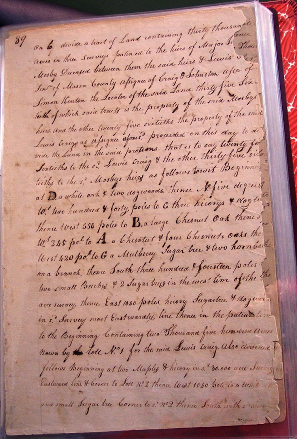
Pg 89
...on to divide a tract of land
containing thirty thousand acres in three surveys patented to the heirs of Major
John Mosby Deceased between them the said heirs and Lewis Craig Sen of Mason
County assignee of Craig (&) Johnston assignees of Simon Kenton the Locator
of the said land. Thirty five
sixtieth of which said tracts is the property of the said Mosbys heirs and the
other twenty five sixtieths the property of the said Lewis Craig as assignee
aforesaid produced on this day to divide the land in the said portions that is
to say twenty five sixtieths to the said Lewis Craig and the other thirty five
sixtieths to the said Mosbys heirs as follows to wit
Beginning at D a white oak and two
dogwoods thence North five degrees West two hundred and forty poles to C three
hickorys and dogwood thence West 550 poles to B a large chestnet oak thence [
? ] West 245 Poles to A a chestnut & four chestnuts oaks thence
West 420 poles to G a mulberry sugar tree and two hornbeams [
? ] on a branch, thence South three hundred & fourteen poles to
two small beeches and 2 sugar trees in the west line of the area survey.
Thence East 1040 poles hicory sugartree 4 dogwoods in said survey most
eastwardly line thence in the patent line to the beginning, Containing two
thousand five hundred acres (k)nown by Lott
No 1 for the said Lewis Craig.
Also divided follows Beginning at two
maples and hicory in said 30,000 acre survey Eastward line & corner to Lott
No 2 thence West 1040 Poles to a white oak and small sugar tree corner to
said No 2 thence South with said survey
Pg 90
west line four
hundred & 4 poles to two buckeys &
one hornbeam on a branch on south east corner to Lott No 4 thence East 1000 poles to a black ash & gum tree in said
Eastward line & corner to said Lott
No 4
then with the patent line Northwardly to the Beginning containing two thousand
five hundred acres and (k)nown by Lott
No 3 for the said Lewis Craig.
Also divided as follows Beginning at
four sycamores & Honey Locust on the west bank of Foxes Creek and in the
patent line, then West 1330 poles with the line of No 6 to a beech & two buckeys corner to said Lott
No 6 thence with the old line North three hundred and thirty three poles to
two white walnuts 4 elm corner to Lott No
4 thence East 1200 poles to a corner to said No
4 in the eastern most line & with the old patent lines Southwardly to
the beginning containing two thousand five hundred acres and (k)nown by Lott No 5 for the Lewis Craig.
Also divided as follows beginning at a
hicory poplar & dogwood on a branch corner to Lott No 9 thence West thirteen hundred and sixty five poles to three
white oaks on the point of a ridge in said 30,000 acre survey west line &
corner to said Lott No 9 thence North
three hundred and ten poles to two sugar trees and dogwood corner to Lott
No 7 thence East 1360 poles to two hicorys & dogwood corner to said Lott No 7 thence with the old line of said survey S.S.E. 313 poles
to the beginning containing two thousand five hundred and 60 acres and (k)nown
by Lott No 8
for the said Lewis Craig.
Also divided as follows beginning at two
white oaks corner to Lott No 12
thence West 1200 pole crossing Foxes creek twice to a buckeye ash and beech on a
branch corner to Lott No 12 thence
with the West line of said 30,000 acre survey North two hundred eighty poles
crossing Foxes creek to two ashes and sugar tree corner to
Pg 91
Lott
No 10 thence East 1250 pole crossing Foxes creek
to three white oaks in the East line of said survey and corner to Lott
No 10 thence with the old patent lines to the beginning containing two
thousand four hundred and forty acres and (k)nown by Lott
No 11 for the said Lew Craig the above five tracts of land as
described as his equal tenty five sixtieths in quantity & quality to have
and to hold the said quantity of twelve thousand five hundred acres to him the
Lewis Craig his heirs & assigns forever free and clear from the let molestation and hindrance of
them the said heirs of John Mosby or their heirs forever and to hold to him the
said Lewis Craig his heirs in severalty and no longer subject to the claim of
them the said John Mosbys heirs.
Also divided the tracts of land as follows
the south west corner to Lewis Craigs Lott
No 1 thence South with the west line of said 30,000 acre survey three
hundred & eighty one poles to a while oak and small sugar tree corner to
Craig Lott No 3 & with the line
of the same East & with Lott No 1
and binding on the old patent to include two thousand five hundred acres and (k)nown
by Lott No 2 for the heirs of John
Mosby.
Also divided as follows Beginning at two
buckeyes and two hornbeams corner to the said Lewis Craig Lott No 3 thence South with the old line three hundred & eighty
poles to two white walnuts and elm corner to said Craig Lott No 5 & with the line of the same and the line of No
3 East & to the old patent line to include two thousand five hundred
acres and (k)nown by Lott No 4 for the said heirs of
John Mosby.
Also divided as follows Beginning at a birch
& two buckeyes corner to said Lewis Craig Lott
Pg 92
No 5
thence South three hundred & ten poles to a beech elm & white oak also
South three hundred & twenty poles to two sugar trees & dogwood corner
to said Lewis Craig Lott No 8 xxxx
the line of the same & the line of No
5 East to the old patent line to include five thousand one hundred &
fifty acres and (k)nown by Lotts
No 6 & No 7 for the said heirs of John
Mosby.
Also divided as follows Beginning at three
white oaks corner to said Lewis Craig Lott
No 8 thence South six hundred & fifty poles to two ashes and sugar tree
corner to said Craig Lott No 11 &
with the line of the same of the line of No 8 East to the old patent line to include five Thousand acres and
(k)nown by Lotts
No 9 & No
10 for the said heirs of John Mosby.
Also divided as follows Beginning at a buckeye ash & beech corner to said Lewis Craig Lott No 11 thence with the old patent line South three hundred & fifty pole to a large white oak & as the south west corner to said 30,000 acre survey & with the old line East and binding on Lott no 11 East to include two thousand three hundred & fifty acres & (k)nown by Lott No 12 for the heirs of John Mosby the above seven tracts of land containing seventee thousand five hundred acres to have and to hold the said tract of land to them the said John Mosbys heirs and their heirs forever in severalty and free and clear from the claim of him the said Lewis Craig as assignee of aforesaid & his heirs & assigns forever. And we the said commissioners do certify and declare that the above is a true division in witness whereof we the said commissioners have hereunto set our hands & seals this 12th day of June 1798.
John Hart
Hugh Sutton
Pg 93
At a court held for Fleming County the 9th day of July 1798 This division of lands between the heirs of John Mosby deceased and Lewis Craig was returned by the commissioners and ordered to be recorded teste Joshua Stockton.
Articles of agreement made and entered into
this second day of March 1782 between Simon Kenton of Lincoln County of the one
part and John Mosby of Powhatan County on the other part witnesseth that the
said Kenton hath received from the said Mosby warrants for sixty thousand acres
land which he the said Kenton engageth to locate as soon as possible on the best
vacant and unappropriated land he can find. The said Mosby on his part engageth to give unto the said
Kenton twenty five sixtieth parts of all such lands as he shall properly secure
to defray every expence that may be attending thereon the division of the said
land after it may be severed each party agree that it shall be divided paying
attention to the quality of the said land by some indifferent person &
choice obtained by lol
for the faithful performance of the above articles each of us bind ourselves our
heirs to the other his heirs in the penal sum of five thousand pounds 5
pence to be paid by the party or
Pg 94
his heirs failing to comply herewith to the other or his heirs on demand. In witness whereof we have hereunto set our hands and affixed our seals the day and year above written
Witness Fras McBridge
Simon Kenton
John Mosby
I do assign overall my rights title and interest of the within article to John Craig and Robert Johnston this 24th day of April 1787.
Simon Ken(ton)
John Willson
James Turner
I assign all my interest of the within to Robt Johnson and Elijah Craig trustees to John Craig May 18, 1891.
Teste Toliver Craig
Robt Johnson
We assign of the within bond to Lewis Craig
eleven thousand five hundred acres a part of Mosbys 30,000 entry 3,100 acres of
his 10,000 entry on main Licking and 4166 being 25/60ths of his
10,000 on the head of Johnson Fork the said Craig is to let Simon Kenton have
1500 acres choice in in one tract to be taken out of the quantities herein given
up to said Craig this is only giving up John Craigs rights Dec the 8th
1798.
Robt Johnston trustee to John Craig
Elijah Craig trustee to John Craig
Pg 95
At a court held for Fleming County the 9th day of July 1798 This article of agreement between Kenton and Mosby together with the assignments thereon was ordered to be recorded.
Teste Joshua Stockton